Today's route snaked its way between some large towns (Burnley, Bacup and Littleborough to the right, and Hebden Bridge and Todmorden to the left), but high enough to feel I was in the countryside.
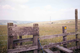
After a pleasant walk along Black Hameldon, the Watershed drops down to the ancient route The Long Causeway which now runs alongside the Coal Clough Wind Farm (which I actually found quite nice to walk past). I was amused to see the sign by the stile saying "single file please" (see photo) - difficult to imagine two people doing it at the same time.
I was given a lift by farmer James down the A646 and back again to do some essential shopping, and then there was a stiff climb up Thieveley Scout and Pike on the Burnley Way. The sun was out, and I enjoyed a cider-facilitated snooze after lunch.
I continued on paths including the Rossendale Way onto map 109, and came down to Calderbrook at 7pm. I had an unsatisfactory meal at a too-posh pub, feeling out of place - too smelly and dishevelled - and then over the Rochdale Canal and up to camp just below the Light Hazzles Reservoir at 960200.
About this blog
The journey from John o'Groats to Land's End took place in 14 sections, starting in 1996 (a week or so each year). The idea came to me in 1995 and I completed the British JoGLE Watershed in June 2009.
I was joined by a number of relations and friends from time to time. Most notable among my walking companions were my son Tim (7 sections) and nephews Peter and Jonny.
After walking the first section in 1996 I discovered that Dave Hewitt had already pioneered the Scottish Watershed (to Cape Wrath) in 1987, and had published his excellent account Walking the Watershed in 1994. We have been in touch since then, and he has been a great encouragement.
A simple definition of the watershed is that any rain falling to the left of the path finishes in the North Sea or English Channel, and anything to the right flows into the Atlantic Ocean, the Irish Sea or the Bristol Channel.
I believe that this was the first walk along the full length of the British JoGLE Watershed. I became aware just after I completed the journey that the late Mike Allen walked a slightly different version (from Land's End to Cape Wrath) between 1988 and 1994, so he will have covered the same ground apart from the most north-easterly 220km.
There have subsequently been several walks and publications about parts of the JoGLE watershed, including Peter Wright's 2010 Ribbon of Wildness account of his Scottish section walked in 2005, which has brought the subject of watershed walking in the UK to a wider audience.
I hope you enjoy this blog. I published a full account in 2025 under the title Walking the British Watershed: John o'Groats to Land's End without crossing flowing water. A summary of the walk also appeared in The Angry Corrie volume 76 in 2009.
Malcolm Wylie.


No comments:
Post a Comment